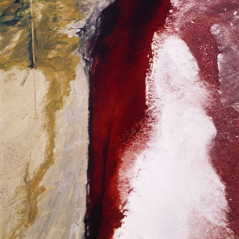
David Maisel, Sausalito, California, USA
Black Maps
The Black Maps Project "Black Maps comprises aerial photographs of environmentally impacted landscapes. The depiction of these damaged wastelands, where human efforts have eradicated the natural order, are both spectacular and horrifying. Although these photographs evidence the devastation of these sites, they also transcribe interior, psychic landscapes that are profoundly disturbing- for, as otherworldly as the images may seem, they depict a shattered reality of our own making.
The photographs in this series are presented as 48"-x-48" color C-prints. These images are meant neither to vilify nor to glorify their content, but rather to expand our notions of what constitutes landscape art. I seek to reveal the landscape in something other than purely visual terms, the photograph transcribing it as an archetypal space of destruction and ruin that mirrors the darker corners of our consciousness.
A current chapter in this body of work is The Lake Project, which comprises images from Owens Lake, the site of a formerly 200 square-mile lake in California on the eastern side of the Sierra Mountains. Beginning in 1913, the Owens River was diverted into the Owens Valley Aqueduct, to bring water to Los Angeles. By 1926, the lake had been depleted, exposing vast mineral flats and transforming a fertile valley into an arid stretch of land. The concentration of minerals in the small amount of water remaining in Owens Lake is so artificially high that blooms of microscopic bacterial organisms result, turning the liquid a deep, bloody red. Viewed from the air, vestiges of the lake appear as a river of blood, a microchip, a bisected vein, or a galaxy’s map. It is this contemporary version of the sublime that I find compelling.
The most recent chapter of my work is Terminal Mirage. Inspired by Robert Smithson’s writings on the Great Salt Lake, I have begun an aerial survey of this surreal, apocalyptic region. I have photographed Smithson's Spiral Jetty- it is above the surface of the lake for the first time in decades, encrusted with salt; the water surrounding the jetty is blood red. I have also made aerial images at the Tooele Army Depot, where 900 munitions storage igloos sprawl across the valley floor, and at the site of evaporation ponds covering some 40,000 acres.
As Smithson stated, "The sense of the earth as a map undergoing disruption leads the artist to the realization that nothing is certain or formal." Maps, like photographs, are made to offer an objective overview, a means to comprehend our location; they are both place and concept, figurative and abstract. But a map that is black, as the title of this work suggests, is a kind of negation. Black maps are indeed unknowable and unnamable; they are ciphers. Perhaps these are the only kinds of pictures, with their compelling ambiguities, with which we can mark the demise of these landscapes."
David Maisel, Sausalito, California, USA May 2004


